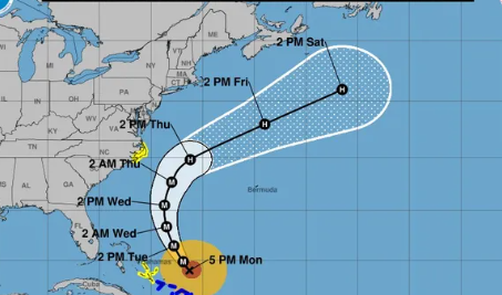
Hurricane Erin started forming on August 11, 2025. The hurricane is unusually big, with tropical wind storms spanning about 230 miles from the middle of the eye. Hurricane Erin is about 575 miles wide from one end to the other. It is forecasted to get even bigger as it has thrown back into the Atlantic Ocean and has set north to the Arctic Ocean. Recent news articles say that the eye of Hurricane Erin is not planned to hit the US. The plan for this hurricane is to make an unusual turn on the East Coast. Though the eye is not forecasted to hit the US, the Eastern Seaboard may hit the states on the East Coast, including Florida, North Carolina, South Carolina, Maryland and Maine. The Outer Banks, islands that are off the coast of North Carolina, there is a tropical storm warning. They’re supposed to get heavy rain and winds up to 40 mph.
A high surf advisory has been issued because of this hurricane, with waves up to 20 feet tall. There has also been a mandatory evacuation order for some of the people in Outer Banks. There were people who stayed, despite the dangers.
Hurricane Erin has changed into a post-tropical cyclone, but is still a small threat. There is still a lot of flooding and high surf advisories happening in the East Coast. Though hurricane Erin is almost over, it has caused a chain effect for many more hurricanes to form. Tropical storm Fernand came from Hurricane Erin. Fernand will not hit the US, but it will follow in the path of Erin.
There have only been 41 recorded category 5 hurricanes in one hundred years, Hurricane Erin being one of them. Hurricane Erin hit category 5 on Saturday, August 16th. There were 16 deaths in all, 9 in Florida and 7 in Jamaica. Although it did not make landfall, it still caused great damage to the states of the Eastern Coast.


